Madagascar Volcanoes
-
Vakinankaratra
-
Nosy-Be
-
Itasy Volcanic Field
-
Vakinankaratra
-
Itasy Volcanic Field
-
Nosy-Be
-
Vakinankaratra
-
Vakinankaratra
-
Nosy-Be
-
Nosy-Be
-
Vakinankaratra
-
Ambre-Bobaomby
Madagascar has 5 Holocene volcanoes. Note that as a scientific organization we provide these listings for informational purposes only, with no international legal or policy implications. Volcanoes will be included on this list if they are within the boundaries of a country, on a shared boundary or area, in a remote territory, or within a maritime Exclusive Economic Zone. Bolded volcanoes have erupted within the past 20 years. Suggestions and data updates are always welcome ().
| Volcano Name | Location | Last Eruption | Primary Volcano Type |
|---|---|---|---|
| Ambre-Bobaomby | Northern Madagascar | Unknown - Evidence Credible | Volcanic field |
| Ankaizina Field | Northern Madagascar | Unknown - Evidence Credible | Volcanic field |
| Itasy Volcanic Field | Central Madagascar | 6050 BCE | Volcanic field |
| Nosy-Be | Northern Madagascar | Unknown - Evidence Credible | Volcanic field |
| Vakinankaratra | Central Madagascar | Unknown - Evidence Credible | Volcanic field |
Chronological listing of known Holocene eruptions (confirmed or uncertain) from volcanoes in Madagascar. Bolded eruptions indicate continuing activity.
| Volcano Name | Start Date | Stop Date | Certainty | VEI | Evidence |
|---|---|---|---|---|---|
| Itasy Volcanic Field | 6050 BCE (in or before) | Unknown | Confirmed | Isotopic: 14C (uncalibrated) | |
| Itasy Volcanic Field | 8301 BCE ± 139 years | Unknown | Confirmed | Isotopic: 14C (calibrated) |
Madagascar has 0 Pleistocene volcanoes. Note that as a scientific organization we provide these listings for informational purposes only, with no international legal or policy implications. Volcanoes will be included on this list if they are within the boundaries of a country, on a shared boundary or area, in a remote territory, or within a maritime Exclusive Economic Zone. Suggestions and data updates are always welcome ().
There are 12 photos available for volcanoes in Madagascar.
 The Itasy volcanic field in central Madagascar contains a diverse assemblage of volcanic landforms, including scoria cones, lava domes, and maars. Activity began in the Pliocene and has continued into the Holocene. A trachytic maar was formed near Saovinandriana at the beginning of the Hololcene, and several other crater lakes are present. Thermal activity in the form of hot springs, and mild seismicity continues at Itasy.
 Copyrighted photo by Katia and Maurice Krafft, 1973.
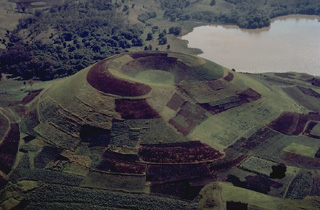 The Itasy volcanic field in central Madagascar contains numerous scoria cones, lava domes, and maar craters. The entire surface of this scoria cone, which has a shallow summit crater that is breached to the right, is mantled by geometric croplands of local farmers.
Copyrighted photo by Katia and Maurice Krafft, 1973.
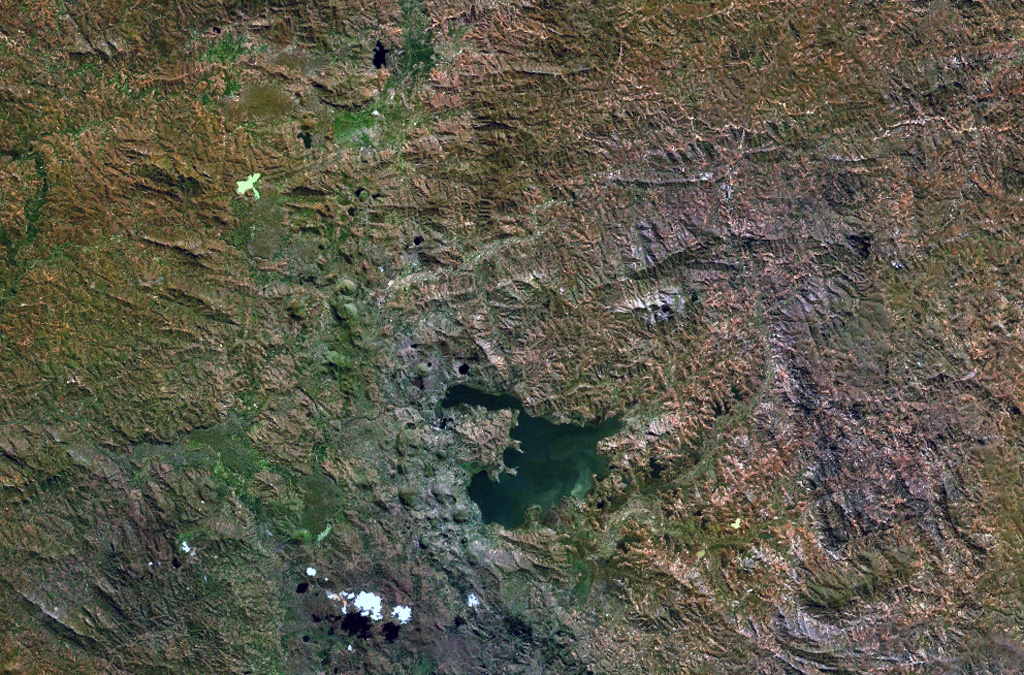
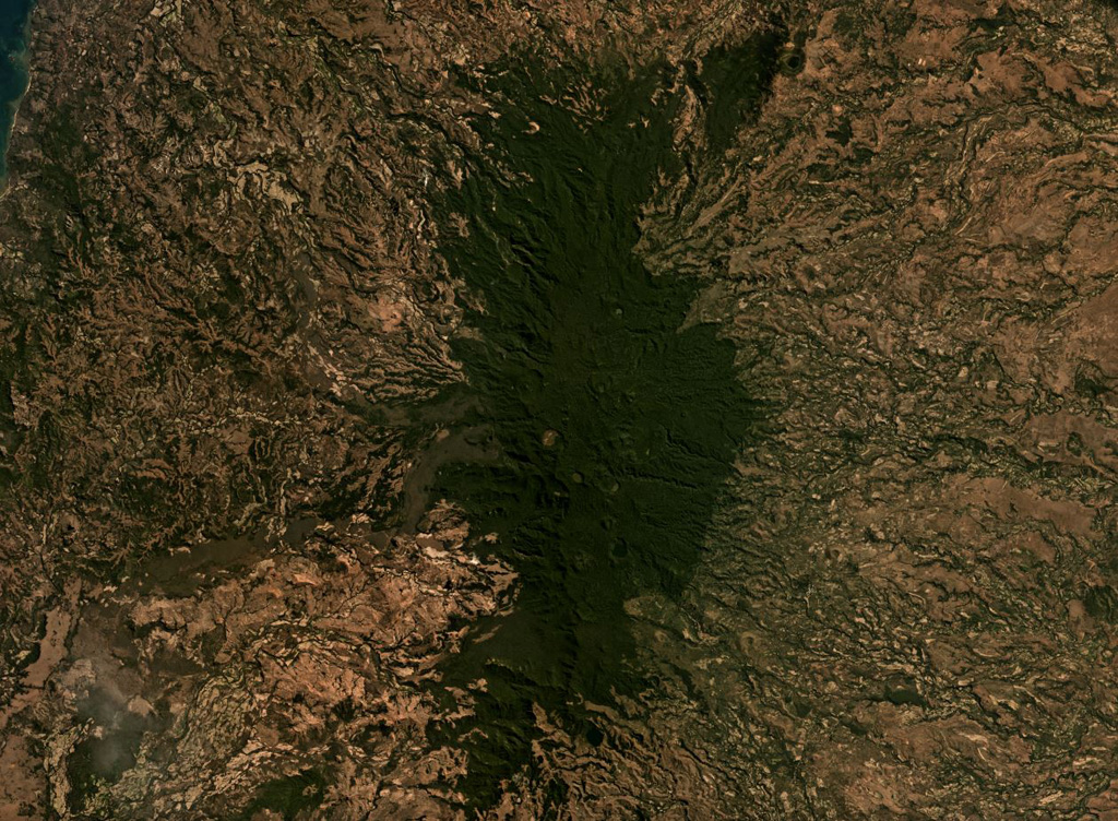
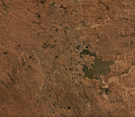
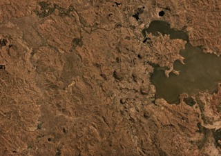 The Itasy Volcanic Field in central Madagascar covers an area of around 1,600 km2, some of which is seen here beside Lake Itasy in this September 2019 Planet Labs satellite image mosaic (N at the top). Several of the 131 identified scoria cones are in this area, as well as some lake-filled maar craters.
Satellite image courtesy of Planet Labs Inc., 2019 (https://www.planet.com/).
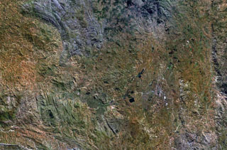
 The Itasy volcanic field in central Madagascar lies W of Lake Itasy (lower center) and consists of a N-S-trending chain of scoria cones, lava domes, and maars. Several small dark-colored, lake-filled maars can be seen in the NASA Landsat image (N to the top), one of which lies just above the NW arm of Lake Itasy. Early eruptions producing trachytic lava domes and basanitic lava flows were followed by the effusion of trachytic lava flows and recent Vulcanian eruptions. Mild seismicity and hot spring activity continue at Itasy.
NASA Landsat 7 image (worldwind.arc.nasa.gov)
 The Ambre-Bobaomby volcanic field forms the northernmost region of Madagascar, shown in this July 2019 Planet Labs satellite image monthly mosaic (N is at the top; this image is approximately 47 km across). The edifice shown here is the Massif d’Ambre, and the Bobaomby field continues to the north. The Massif d’Ambre contains lava flows, spatter cones, tuff rings, pyroclastic flow deposits, and tephra, with some craters visible down the apex of the N-S trending edifice.
Satellite image courtesy of Planet Labs Inc., 2019 (https://www.planet.com/).
 This vegetated lava dome is one of many at the Itasy volcanic field in central Madagascar. A steep-sided viscous lava flow descends to the left of the summit. Lateral levees at the margins of the flow form the distinct ridges at the lower left below a sharp bend in the lava flow.
Copyrighted photo by Katia and Maurice Krafft, 1973.
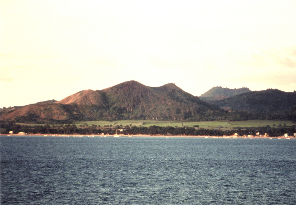
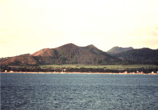 Scoria cones line the shores of Nosy-Be island off the NW coast of Madagascar and have erupted recent basaltic lava flows. Many large crater lakes are found in the central part of the island. The Nosy-Be volcanics overlie Mesozoic limestones and other sedimentary rocks. Two periods of activity occurred, with initial eruptions of fluid lava flows from the W side of the massif followed by the construction of numerous scoria cones on the western plain.
Copyrighted photo by Stephen and Donna O'Meara, 2002.
 The Ankaizina volcanic field in Northern Madagascar is in the area shown in this Planet Labs satellite image monthly mosaic (N is at the top; this image is approximately 25 km across). The largely vegetated field contains scoria cones and lava flows.
Satellite image courtesy of Planet Labs Inc., 2019 (https://www.planet.com/).
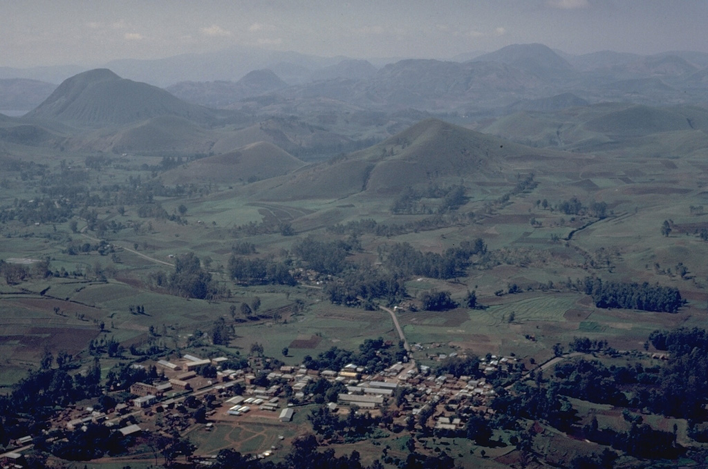
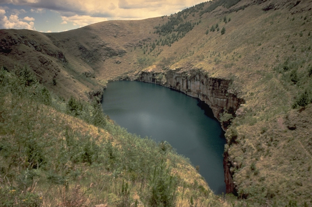
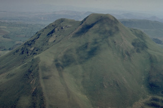
 The Ankaratra volcanic field, the most prominent and volcanologically diverse on Madagascar, covers a 100-km-long area in the central part of the island. Vulcanian eruptions produced several lake-filled craters such as this one. Trachytic lava domes were erupted during the initial stage and massive fissure eruptions created a series of tectonic lakes. The latest activity occurred in the southern part of the massif and produced well-preseved strombolian cinder cones.
 Copyrighted photo by Katia and Maurice Krafft, 1973.
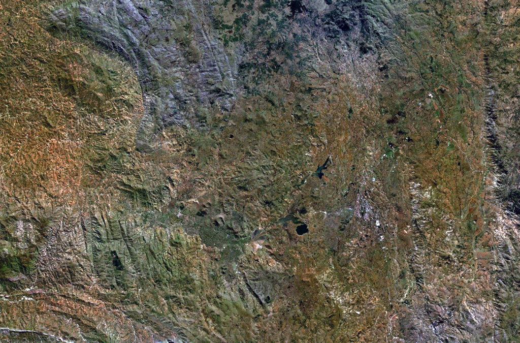
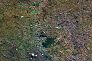
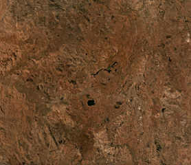 The Vakinankaratra volcanic field covers an area of 3,800 km2 in central Madagascar, some of which is shown in this September 2019 Planet Labs satellite image mosaic (N is at the top). The field contains monogenetic scoria cones, lava flows, lava domes, and maars.
Satellite image courtesy of Planet Labs Inc., 2019 (https://www.planet.com/).
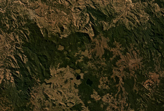
 The Itasy Volcanic Field is a monogenetic field in central Madagascar around Lake Itasy near the center of this September 2019 Planet Labs satellite image mosaic (N at the top). The field contains scoria cones, lava domes, lava flows, and maars across an area of 1,600 km2. There have been 131 scoria cones identified throughout the field.
Satellite image courtesy of Planet Labs Inc., 2019 (https://www.planet.com/).
 The Ankaratra volcanic field in central Madagascar consists of lava domes, fissure vents, scoria cones, and maars. The volcanic field is one of the largest on the island and covers a 100-km-long area in central Madagascar. Hot springs occur at Ranomafana. N is at the top in this NASA Landsat image.
NASA Landsat 7 image (worldwind.arc.nasa.gov)
This is a compilation of Madagascar volcano information sources, such as official monitoring or other government agencies.
| Volcanic Ash Advisory Center | |
|---|---|
| Toulouse Volcanic Ash Advisory Center (VAAC) Notices and Archive | |